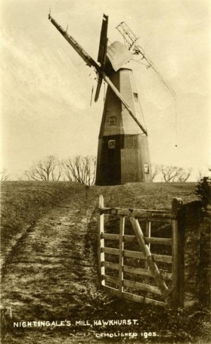
Nightingale's Mill, Hawkhurst
A wind-powered corn mill in the historic county of Kent, England.
See related images and documents.
See images only.
Documentary evidence indicates that Nightingale's Mill originally stood at Gun Green in Hawkhurst parish 0.7 miles N of the A268 and the Oak and Ivy Pub. The mill was built by the Tobitt family in 1821/2 (first assessed for rates in 1822) and is marked on the Hawkhurst Tithe Map at Grid Ref 773307. Edmund Tobitt is recorded as miller in trade directories in the 1840s.
When the Tobitt farms were sold in 1852, the windmill was described as "above average height" and "of good elevation". It was actually advertised for sale twice in 1852; the later advert, in September that year, suggests that there was a lack of interest earlier and it was offered "at a price which will admit its removal and re-erection". The mill must have been dismantled and re-erected on Nightingale's land during 1853. It stood 0.3 miles south of Four Throws and was actually in Sandhurst parish.
It was first assessed for rates in that parish in early 1854 on land tenanted by John Nightingale, who lived in Conghurst Lane, Hawkhurst, and from where there was access to the mill (and from where the photo of the tail-winded mill was taken). Interestingly, Edmund Tobitt continued to operate the mill there from 1854 until at least 1867, followed by his son Samuel. The mill was demolished in 1905.
Full details
| Alternative names | Four Throws Mill, Knowls Mill |
| Power source | Wind |
| Mill type | Smock mill |
| Mill function | Corn mill |
| Archive ID | 9533 |
| Location | Hawkhurst |
| Historic county | Kent |
| Country | England, United Kingdom |
| NGR | TQ 7746 2943 |
| Latitude/longitude | 51.03671100, 0.53086500 |
Location
Gallery
References
- Hawkhurst Overseers' Account books, KHLC P178/12/2, 3, etc (Kent History and Library Centre)
- Hawkhurst Tithe Map: KHLC Dcb/TO/H9B (surveyed 1839-40) and Award: KHLC P178/27/2 (dated November 1840) (Kent History and Library Centre)
- Maidstone Advertiser, 18 May 1852 and South Eastern Gazette 14 Sep 1852
- Ordnance Survey 25 inch map, Kent LXXVIII.7 (1898)
- Sandhurst Overseers' Rate Assessment book KHLC P321/11/5 (Kent History and Library Centre)
Contributors
Tony Singleton
Missing information? Click here to tell us about this mill.


