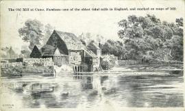
Cams Mill, Fareham
A water-powered corn mill in the historic county of Hampshire, England.
See related images and documents.
See images only.
The mill is shown on the 1856 and 1910 OS maps, but had been demolished by the time of the 1932 map (revised 1930). A building modeled on the original was constructed near the site c 2010 to serve as a restaurant.
Full details
| Alternative names | Fareham Mill |
| Power source | Water |
| Mill type | Watermill |
| River | Wallington River |
| Mill function | Corn mill |
| Archive ID | 13872 |
| Location | Fareham |
| Historic county | Hampshire |
| Country | England, United Kingdom |
| NGR | SU 5872 0623 |
| Latitude/longitude | 50.85265100, -1.16710400 |
Location
Gallery
References
- https://www.camsmill.co.uk/
- Ordnance Survey 25 inch map, Hampshire and Isle of Wight LXXV.9 (1910)
- Ordnance Survey 25 inch map, Hampshire and Isle of Wight LXXV.9 (1932)
- Ordnance Survey six-inch map, Hampshire & Isle of Wight LXXV (1856)
Missing information? Click here to tell us about this mill.


