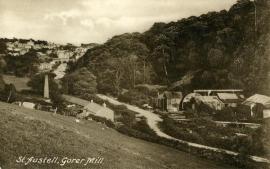
Gover Mill, St Austell
A water-powered bone mill and saw mill in the historic county of Cornwall, England.
See related images and documents.
See images only.
Given as a bone mill on the 1888 OS map (surveyed 1879-1881) and as a saw mill on the 1908 map (revised 1906). Still present on the 1947 map (revised 1938) but now gone.
Full details
| Power source | Water |
| Mill type | Watermill |
| Mill function | Bone mill, Saw mill |
| Archive ID | 12192 |
| Location | St Austell |
| Historic county | Cornwall |
| Country | England, United Kingdom |
| NGR | SX 0030 5287 |
| Latitude/longitude | 50.34180000, -4.80780000 |
Location
Gallery
References
- Ordnance Survey six-inch map, Cornwall L.NE (1888)
- Ordnance Survey six-inch map, Cornwall L.NE (1908)
- Ordnance Survey six-inch map, Cornwall L.NE (1947)
Missing information? Click here to tell us about this mill.


